S'ang District (S'ang)
S'ang District (ស្រុកស្អាង) is a district (srok) of Kandal Province, Cambodia. The district is subdivided into 12 communes (khum) such as Khpob, Kaoh Khael, Kaoh Khsach Tonlea, Krang Yov, Prasat, Preaek Ambel, Preaek Koy, S'ang Phnum, Svay Prateal, Ta Lon, Traeuy Sla, Tuek Vil and 119 villages (phum).
Map - S'ang District (S'ang)
Map


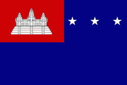
Country - Khmer_Republic
 |
 |
| Flag of Cambodia | |
The main cause of the coup was Norodom Sihanouk's tolerance of North Vietnamese military activity within Cambodia's borders; Vietnamese communist forces had gained de facto control over vast areas of eastern Cambodia as a result. Another important factor was the dire state of the Cambodian economy, an indirect result of Sihanouk's policies of pursuing neutrality.
Currency / Language
| ISO | Currency | Symbol | Significant figures |
|---|---|---|---|
| KHR | Cambodian riel | ៛ | 2 |
| ISO | Language |
|---|---|
| KM | Central Khmer language |
| EN | English language |
| FR | French language |